GEO living labs can accelerate maritime cooperation between corporations and startup Earth Observation technologies to encourage digitization of maritime systems.
Over the last decade, Earth Observation (EO) has grown as more companies and their satellites became dedicated to capturing data of the Earth’s atmosphere, surface, ports, seas and inland waters. At the moment, the maritime industry does not have access to certain sensor data, specific or proxy, or a manual measured value for progress to advance digitization. This prevents the industry of increasing effectiveness within the current process. Geolocation and Earth Observation (GEO) data will bridge this data gap.
Governmental bodies such as the European Commission, through the Copernicus program, and ESA have taken a prominent role in developing the GEO ecosystem, with global coverage within Europe. Through their support services and with increased awareness and interest of the industry, the adoption of GEO data is accelerating and will take a fast leap in the upcoming year.
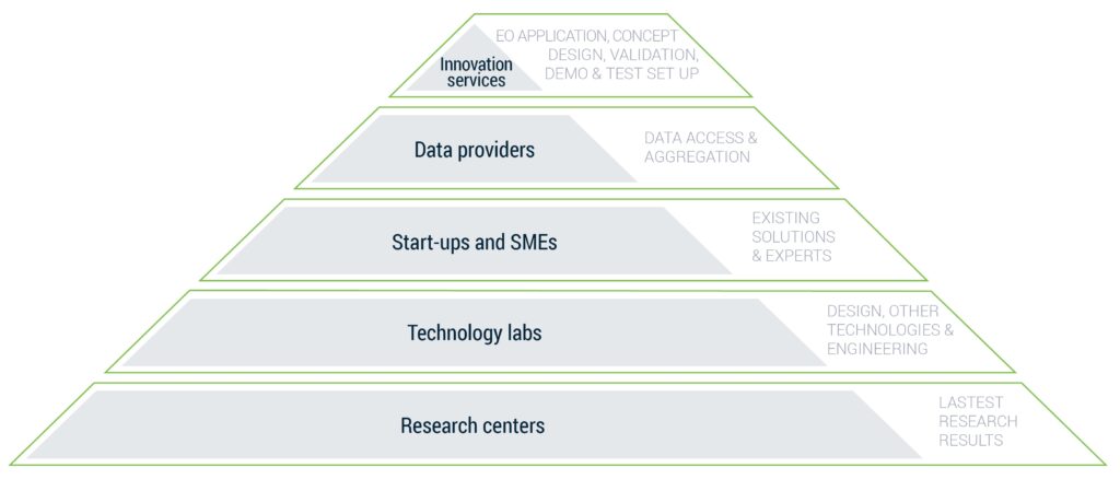
The technology push of GEO service providers has realized quick advances. These developments required focus on GEO experts, IT developers and new IT architectures, but did not focus on a deeper business understanding of applying the added value of technologies. Until now providers have not met the requirements of the maritime industry’s needs and challenges for developing viable, long-term sustainable products and services. Creating such solutions is ongoing, but has not yet resulted in useful cases. Hence fruitful outcomes of such solutions need to be accelerated through a structured yet agile approach to create killer applications. Verhaert decided to launch a living lab focused on lowering the threshold of GEO technologies for industries and to capitalize on the fast growing GEO technological abilities.
My startup Westray has been greatly helped by Verhaert from receiving support and advice how to access to space technology and how to process the available data. The support combined with the funding opportunities really kick our startup further.
Kenneth Ruyts, Founder Westray
GEO adoption, however, is not easily achieved for large corporations, for example in the maritime sector, such as ports, logistic companies, shipping companies and many more. Fostering digitization demands big organizational changes, investments and new, often uncertain product introduction. Building capabilities in the underlying technologies, such as Geographical Information Systems (GIS), big data analytics, artificial intelligence and data engineering, all include high innovation risks if developed by companies alone. Nevertheless, larger enterprises are managing many of these risks. Larger enterprises are now also striving to improve their organization’s agility to keep up with the fast-paced changes in which the market is evolving, inspired by start-ups with agile and market pivoting innovation methods that can quickly adopt these fast-paced technology changes. Each of the thematically selected start-ups in the GEO living labs will have taken up one or more high risk technology developments in the past. Maritime actors can tap into those learnings without significantly increasing innovation risk. Access to state-of-the-art developed or developing technologies present within the start-ups will reduce development time and cost.
GEO living labs will enable the added value of several startup’s, the goal-oriented search approach for corporate innovation and benefits for startups and corporate. The GEO living lab aggregates the latest research results, underlying technologies, GEO experts and solutions with multiple data sources. Sharing knowledge and insight between the different participants will accelerate feedback loops with each party providing specific subject matter experts.
Working with diverse teams in open innovation structures has proven to enable innovations on old and new products and services at a lower cost.
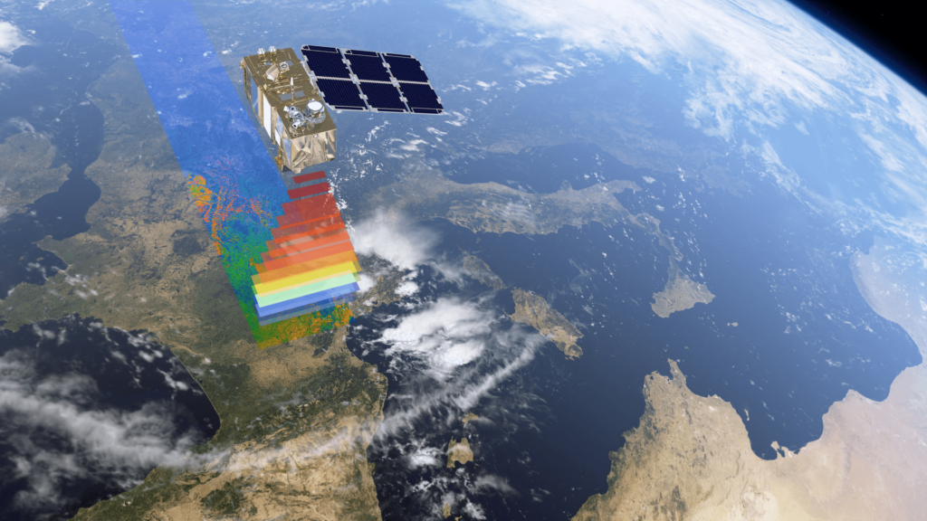
Stakeholders in the maritime and port sector seem to be clear potential beneficiaries of the GEO technology and collaboration with start-ups through GEO living labs. Many start-ups we created in our role of Copernicus Incubator, have used satellite sensors to provide ocean characteristics for marine and port monitoring. These data sets originate from imaging spectroradiometer (MODIS), color imager (GOCI), visible infrared radiometer (VIIRS) each on board of different satellites. Today many EO generating satellites available, which enables detecting many parameters.
Let’s examine some interesting ones:
-
- Sea ice thickness: ESA’s SMOS and NASA’s SMAP satellites provide accurate soil moisture information. Measurements from Copernicus Sentinel-2 satellite can then be applied to improve the resolution. By combining measurements from all of these sensors the spatial resolution is increased from 25 km by 25 km to 100 m by 100 m.
- Sea surface height: The main application of the Sentinel-3 satellite in relation to climate is in determining mean sea level rise due to global warming.
- Sea Surface Wave (SWH): This can be derived from altimeter data (Jason-3 and Sentinel-3A) within 3 hours after data acquisition. These wave measurements come from two main techniques: altimetry and Synthetic Aperture Radar. The Sentinel-3A accuracy reaches an astonishing 4% for Near Real-Time products and even 1% for Slow Time Critical (STC products), that is 2 cm by 2 m SWH.
- Surface temperature: Many satellites measure the emitted thermal energy, so they are able to determine sea surface temperature (SST). This is an important parameter for understanding ocean water circulation. In case of large unauthorized oil spills, these data can effectively pinpoint the oil spilled areas, as they appear will cooler than the water surface due to their lower emissivity.
- Currents: Sentinel-3 on board sensors study the ocean topography including mean sea level, wave height, wind speed over the surface, sea-ice, ocean currents, Kelvin and Rossby waves, eddies and tides.
- Turbidity: Satellite images cannot only characterize turbidity levels on a regional scale, but also in the vicinity and slipstream of dredging vessels.
- Chlorophyll-a & chlorophyll fluorescence: High concentrations of chlorophyll (a photosynthetic pigment in phytoplankton and macroalgae) in water cause high reflectance in the green region (500–600 nm) and high absorption in the blue and red regions. As a result, they are detectable by spectral satellite camera’s. Chlorophyll fluorescence can be detected by sensors with fine spectral resolution in the far-red and NIR.
- Algae bloom: The growth of algae blocks sunlight and produces an anoxic or hypoxic condition (dissolved oxygen is depleted from the water column), which is hazardous to marine life. It can even affect the movement of ships. Bloom measurement by satellites creates specific requirements such as (i) no or low cloud cover, (ii) the bloom should be near to the surface, and (iii) the bloom must cause the coloration of the water.
- Sea ice thickness: ESA’s SMOS and NASA’s SMAP satellites provide accurate soil moisture information. Measurements from Copernicus Sentinel-2 satellite can then be applied to improve the resolution. By combining measurements from all of these sensors the spatial resolution is increased from 25 km by 25 km to 100 m by 100 m.
This isn’t all, EO generating satellites have been used to measures far more parameters, such as pollutants, ocean depths, nutrients, salinity, large ships and piracy or ‘dark’ vessels.
A downside for satellite data that is mentioned often, is that it takes several days to access the data, and that global coverage is not always available in the require uptime frequency. To exemplify, Sentinel-3 has an orbital cycle of 27 days, which is the time for the satellite to pass over the same geographical point on the ground. However, Planet, a prominent commercial satellite image provider, already achieves daily global coverage with their constellation of Dove satellites. The ambition of Planet is to go down to high resolution imaging every hour. Another way to increase the number of observations, is by combining information (data sets) from different satellites.
For instance, Sentinel-2A and Sentinel-2B are placed in the same orbit, flying 180° apart. Every five days, these satellites together cover all land surfaces, large islands, and inland and coastal waters between latitudes 84°S and 84°N.
Key takeaways:
-
- Geolocation and Earth Observation data breadth and access are improving with quick strides.
- This data can fill the existing data gap to accelerate digitization of the maritime industry.
- A GEO living lab is an ideal environment for exploring, refining use-cases, and testing new GEO applications by accessing expert knowledge on the newest technology developments in different industries.
Download the perspective
Looking for solutions to innovate?
Leave us your email and get in contact with Pieter Deleye to help you with your innovation process.